3D Reconstruction Software
Get3D Mapper
One automated platform—from raw data to decision-ready 3D models.
Driving 3D Mapping Intelligence
Massive LiDAR and image datasets often slow down processing and break consistency across outputs. Get3D Mapper handles large-scale inputs through cluster-powered workflows built for speed and stability. It’s AI-driven reconstruction enhances geometry, refines textures, and removes errors automatically, delivering scalable, rapid and highly accurate 3D modelling. This 3D modelling software seamlessly integrates multi-source data, eliminating fragmented workflows. Outputs remain consistent, high-fidelity, and ready for analysis and decision-making. From raw inputs to final models, every stage connects smoothly and performs at scale, transforming large datasets into results with greater efficiency.
Key Features
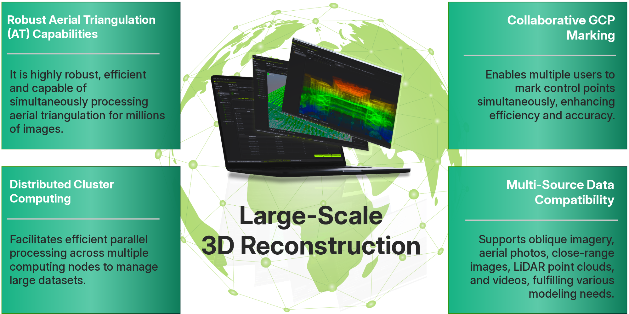
Large-Scale 3D Reconstruction Capability
High-Speed Processing Intensity
Cluster-Based Processing Engine
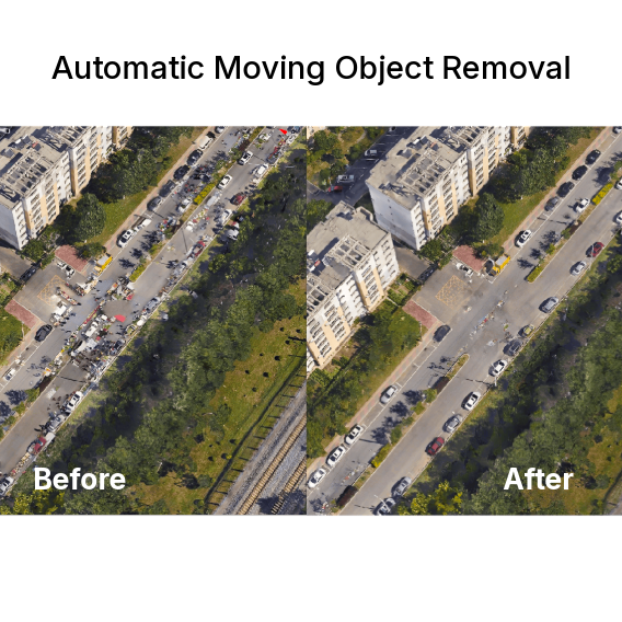
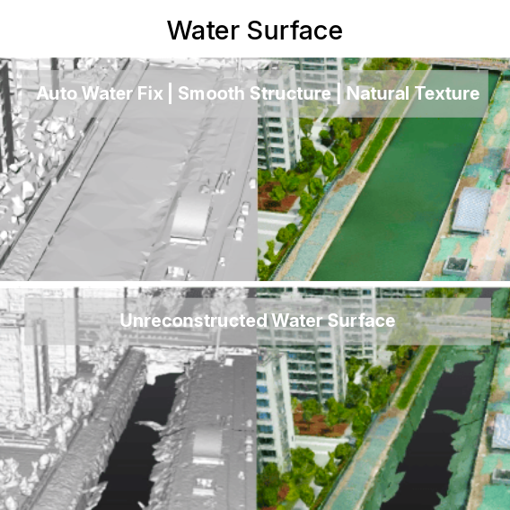
Superior Output Quality Visualisation
Precision and Accuracy Control
Multi-Source Data Fusion
Large-scale 3D Reconstruction Intelligence
High-Speed Processing
High Automation:
Automatically conducts aerial triangulation and reconstruction, reducing manual intervention and enhancing efficiency.
Optimised CPU & GPU Acceleration:
Maximises CPU and GPU capabilities for parallel processing, significantly decreasing AT and reconstruction time.
Transforms large datasets into results with greater efficiency.
Efficiently converts data into high-quality outputs.
Superior Output Quality
Generate highly detailed and accurate reconstruction outputs, ensuring reliable results for mapping, modelling, and analysis workflows.
- High-Fidelity Textures
- Seamless Block Consistency
- Advanced Shadow Processing
- Automatic Moving
- Object Removal
- Automated Water Surface Enhancement
- Intelligent Noise Reduction
- Enhanced Edge Detail Preservation
Greater Quality Performance
Powered by AI-Driven Algorithms, Get3D Mapper delivers faster processing, highly complete geometry, and high-quality textures compared to others.
Get3D Mapper delivers centimetre-level accuracy and ensures dependable results, maintaining consistent accuracy across large-scale environments.
Strong alignment improves measurement and modelling precision, and stable outputs support critical decision-making workflows.
It processes complex datasets with greater consistency, preserving detail across varied terrain, structures, and environments. Reliable reconstruction quality reduces rework and enables faster project delivery.
AT Efficiency
| Data | Image Resolution | Image Count | Area | Ground Resolution | Time |
|---|---|---|---|---|---|
| Data 1 | 24 MP | 50,030 | 11.5 km² | 3 cm | 1.2h |
| Data 2 | 42 MP | 52,350 | 10.9 km² | 2.5 cm | 2.1h |
| Data 3 | 100 MP | 35,266 | 74.1 km² | 5 cm | 1.9h |
| Data 4 | 24 MP | 161,590 | 32.5 km² | 3 cm | 4.1h |
Test environment: One 10-node Get3D Farm (Intel Xeon E-2378, NVIDIA GeForce RTX 3080Ti, 128GB DDR4 each)
Reconstruction Efficiency
| Data | Image Resolution | Image Count | Area | Ground Resolution | Time |
|---|---|---|---|---|---|
| Data 1 | 24 MP | 50,030 | 11.5 km² | 3 cm | 8.5h |
| Data 2 | 42 MP | 52,350 | 10.9 km² | 2.5 cm | 10.3h |
| Data 3 | 100 MP | 35,266 | 74.1 km² | 5 cm | 27.6h |
Test environment: One 10-node Get3D Farm (Intel Xeon E-2378, NVIDIA GeForce RTX 3080Ti, 128GB DDR4 each)
See real-world 3D modelling from Get3D Mapper.
City
Culture Heritage
Mining
Highway
Handle large-scale inputs and reconstruct data into decision-ready 3D models. Now bring precision, swiftness, and reliability across every application. Unlock the true value of your data and turn insights into impact.
Ready to get started?
With Mirai, now start your scalable 3D reconstruction without processing limits.